Holmes’s 1882 Grand Canyon panorama joins three views into one long image, combining geological structure with a vast sense of scale.
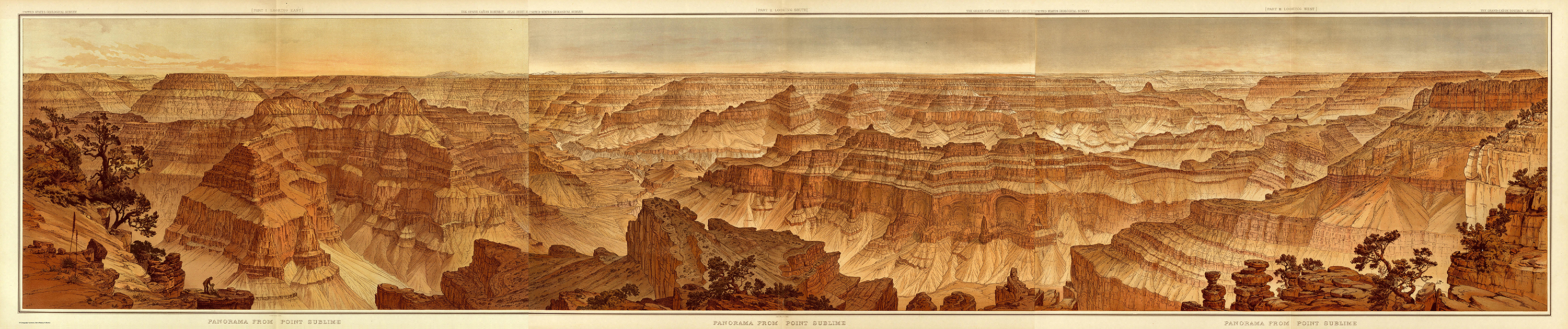
The picture seems to go on longer than the eye expects. Cliffs rise in bands, drop into shadow, and reappear farther away. Small patches of vegetation cling to the foreground while the horizon stretches across nearly the entire width. The Grand Canyon has been made into a page that resists a single glance.
William Henry Holmes created this Panorama from Point Sublime for the atlas accompanying Clarence E. Dutton’s 1882 Tertiary History of the Grand Cañon District. The image shown here is a digital joining of three original sheets, supplied by the U.S. Capitol Visitor Center from the Library of Congress material.
A view made by turning
The three sheets look east, south, and west from Point Sublime on the North Rim. The Library of Congress describes the whole as a 270-degree panorama. It gathers a sweep of landscape that a viewer would need to turn to take in. It is therefore different from a picture pretending to show everything within an ordinary forward glance.
The joins remain useful to notice. They reveal the image’s structure and the practical problem of fitting a vast prospect into a bound atlas. A digital screen can make the panorama appear seamless, but its original readers encountered it as printed sheets.
Follow one of the light bands across the canyon walls. It disappears behind a nearer form, then returns on another cliff. The repetition helps separate the landscape into relationships rather than leaving it as a collection of dramatic peaks. In our reading, those repeated bands are what hold the immense view together.
Two people almost disappear
Near the far-left foreground, two small figures occupy a ledge. Linda Hall Library identifies them as Holmes and Dutton, with the artist at work. They are easily missed at the scale of a thumbnail. Once noticed, they give the rock walls a human measure and make the act of recording the landscape part of the image.
Their smallness should not suggest that they were the first people to know the canyon. The Library of Congress places the nineteenth-century surveys within a much longer history of Indigenous habitation and knowledge. The atlas records a particular government survey and publishing project, not the beginning of the place’s human history.
The U.S. Geological Survey commissioned Holmes and Thomas Moran to provide images for Dutton’s work. This panorama is Holmes’s. Its broad sweep belongs with maps and scientific descriptions, yet the colors and careful arrangement also give it the power of a landscape picture.
Notice how the darkest foreground is interrupted by pale, sunlit rock farther out. Those shifts keep distance legible without reducing every surface to the same kind of detail. The view can be read as depth, as repeated layers, or as a pattern of warm and cool tones.
Its scale becomes most convincing when the eye travels slowly. Start with the two people, follow a band into the distance, and then return to the small ledge. The panorama makes room for two experiences at once: the desire to understand how the canyon is structured, and the difficulty of taking so much structure in.
Artwork & sources
Panorama from Point Sublime, atlas sheets XV–XVII
William Henry Holmes, for Clarence E. Dutton’s USGS atlas · 1882 · Printed color panorama, three sheets; digital composite shown
William Henry Holmes, Panorama from Point Sublime, 1882, USGS atlas to Clarence E. Dutton’s Tertiary History of the Grand Cañon District. Library of Congress, Geography and Map Division. Digital composite supplied by the U.S. Capitol Visitor Center.
View the source object. Image: Public domain: 1882 U.S. Geological Survey publication; faithful digital reproduction.
- U.S. Capitol Visitor Center: the three-sheet digital composite
- Library of Congress: A Landmark Atlas of the Grand Canyon
- Linda Hall Library: William Henry Holmes’s panorama
- Library of Congress: the 1882 atlas and reuse statement
Historical and scientific details are grounded in the sources above. Interpretations of composition are Storied Spark’s own readings. Storied Spark is independent of the collecting institutions.
Comments
Post a Comment